Today Partly Cloudy | Tonight Partly Cloudy |
| 79°F | 63°F |
Highest temperature today = 76.4°F at 1:51 AM
Lowest temperature today= 73.3 °F at 4:36 AM
Average temperature today= 74.7 °F
Highest dewpoint today = 73.6 °F at 1:40 AM
Lowest dewpoint today = 67.1 °F at 4:32 AM
Average dewpoint today = 71.3 °F
Average external humidity today = 89 %
Highest wind chill today = 76.4 °F at 1:51 AM
Lowest wind chill today = 73.3 °F at 4:36 AM
Highest heat index today= 76.4 °F at 1:51 AM
Average heat index today = 74.7 °F
Lowest pressure today = 29.63 inHg at 2:14 AM
Highest wind gust today = 18 MPH at 3:40 AM
Average Wind Speed Today = 5.0 MPH
Highest rain rate today= 0.00 in/h at 4:00 AM
Rain today = 0.00 in
13 MPH
Highest temperature yesterday = 90.4°F at 4:32 PM
Lowest temperature yesterday= 71.5 °F at 10:45 PM
Average temperature yesterday= 80.0 °F
Highest dewpoint yesterday = 76.9 °F at 8:39 PM
Lowest dewpoint yesterday = 66.9 °F at 4:12 PM
Average dewpoint yesterday = 71.1 °F
Average external humidity yesterday = 76 %
Highest wind chill yesterday = 90.4 °F at 4:32 PM
Lowest wind chill yesterday = 71.5 °F at 10:45 PM
Highest heat index yesterday= 97.8 °F at 3:42 PM
Average heat index yesterday = 82.9 °F
Lowest pressure yesterday = 29.65 inHg at 11:50 PM
Highest wind speed yesterday = 30 MPH at 8:48 PM
Average wind speed yesterday= 4.2 MPH
Highest rain rate yesterday= 3.65 in/h at 8:54 PM
Rain yesterday = 0.58 in
Highest temperature this week = 90.4°F on 14 Jun 2026 4:32 PM
Lowest temperature this week = 71.5 °F on 14 Jun 2026 10:45 PM
Average temperature this week = 79.2 °F
Number of frost days this week: 0
Highest dewpoint this week = 76.9 °F on 14 Jun 2026 8:39 PM
Lowest dewpoint this week = 66.9 °F on 14 Jun 2026 4:12 PM
Average dewpoint this week = 71.1 °F
Average external humidity this week = 78 %
Highest wind chill this week = 90.4 °F on 14 Jun 2026 4:32 PM
Lowest wind chill this week = 71.5 °F on 14 Jun 2026 10:45 PM
Highest heat index this week = 97.8 °F on 14 Jun 2026 3:42 PM
Average heat index this week = 81.6 °F
Lowest pressure this week = 29.63 inHg on 15 Jun 2026 2:14 AM
Highest wind speed this week = 30 MPH on 14 Jun 2026 8:48 PM
Average wind speed this week = 4.5 MPH
Highest rain rate this week = 3.65 in/h on 14 Jun 2026 8:54 PM
Rain this week = 0.58 in
Number of rain days this week: 1
Highest temperature last week = 94.7°F on 11 Jun 2026 4:01 PM
Lowest temperature last week = 52.8 °F on 9 Jun 2026 5:23 AM
Average temperature last week = 79.2 °F
Number of frost days last week: 0
Highest dewpoint last week = 79.1 °F on 11 Jun 2026 2:12 PM
Lowest dewpoint last week = 47.0 °F on 8 Jun 2026 10:15 PM
Average dewpoint last week = 67.1 °F
Average external humidity last week = 73 %
Highest wind chill this week = 94.7 °F on 11 Jun 2026 4:01 PM
Lowest wind chill last week = 52.8 °F on 9 Jun 2026 5:23 AM
Highest heat index last week = 110.3 °F on 12 Jun 2026 3:44 PM
Average heat index last week = 79.8 °F
Lowest pressure last week = 29.73 inHg on 12 Jun 2026 5:55 PM
Highest wind speed last week = 23 MPH on 12 Jun 2026 9:16 PM
Average wind speed last week = 3.0 MPH
Highest rain rate last week = 0.13 in/h on 12 Jun 2026 10:13 PM
Rain last week = 0.04 in
Number of rain days last week: 1
Highest temperature this month = 94.7°F on 11 Jun 2026 4:01 PM
Lowest temperature this month = 52.3 °F on 2 Jun 2026 5:43 AM
Average temperature this month = 75.1 °F
Number of frost days this month: 0
Highest dewpoint this month= 79.1 °F on 11 Jun 2026 2:12 PM
Lowest dewpoint this month= 44.1 °F on 14 Jun 2026 4:12 PM
Average dewpoint this month= 63.4 °F
Average external humidity this month = 69 %
Highest wind chill this month = 94.7 °F on 11 Jun 2026 4:01 PM
Lowest wind chill this month= 52.3 °F on 2 Jun 2026 5:43 AM
Highest heat index this month = 110.3 °F on 12 Jun 2026 3:44 PM
Average heat index this month = 76.7 °F
Lowest pressure this month = 29.63 inHg on 15 Jun 2026 2:14 AM
Highest wind speed this month= 30 MPH on 14 Jun 2026 8:48 PM
Average wind speed this month = 3.2 MPH
Highest rain rate this month = 3.65 in/h on 14 Jun 2026 8:54 PM
Rain this month = 0.62 in
Number of rain days this month: 2
| Today Partly Cloudy | Tonight Partly Cloudy |
| 79°F | 63°F |

|

|
| Radar/Satellite images courtesy of NOAA/NWS and Noaa Star GOES Imagery. | |
June so far has been... Warmer than average (75.15°F versus an average of 74.80) Drier than average (0.62 in versus an average total of 2.75) Calmer than average (a wind run of 1,076 miles versus an average of 1,511)
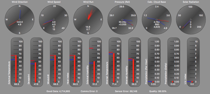
Last Update: 15 Jun 2026 4:36 AM
Current Temp: 73.3 °F (-1.2)
Current Heat Index: 73.3 °F (-1.2)
Current Wind Chill: 73.3°F (-1.2)
Current Dew Point: 67.1°F (-3.9)
Current Humidity: 81 % (-8)
High Today: 76.4 °F at 1:51 AM
Low Today: 73.3 °F at 4:36 AM
Highest Heat Index Today: 76.4 °F at 1:51 AM
Lowest Wind Chill Today: 73.3 °F at 4:36 AM
Current Indoor Temperature 74.3
Click for our Weather Data at AWEKAS
Local Sunrise Time Today: 5:40 AM
Local Sunset Time Today: 8:29 PM
Daylight Time Today: 14:49
Local Sunrise Time Tomorrow: 5:40 AM
Local Sunset Time Tomorrow: 8:29 PM
Daylight Time Tomorrow: 14:49
Last Update: 15 Jun 2026 4:36 AM
Current Pressure: 29.67 inHg (0.02)
Current Wind Direction: NNW
Average Wind Speed: 6 MPH (1)
Highest Wind Gust Today: 18 MPH at 3:40 AM
Highest Wind Reading past 10 Minutes :13mph
The 10 Minute Average Wind Speed : 6.0mph
Current Rainrate: 0.00 in/h (0.00)
Today's Rain: 0.00 in
Rain Days This Month: 2
Current Indoor Humidity 54
Local and Regional Forecast Regional Forecast Discussion NHC Atlantic Storms Toddville Weather Historical Weather History Mid Atlantic River Forecast Center National Weather Service Wakefield, Va
| National Weather Service Forecast for:
3 Miles W Elliott, MD Issued by: National Weather Service Wakefield, VA |
||||||||||||||||||||||||||||||||||||||||
| Updated: 2:32 am EDT Jun 15, 2026 | ||||||||||||||||||||||||||||||||||||||||
| Toddville, MD (ERH) | ||||||||||||||||||||||||||||||||||||||||
|
||||||||||||||||||||||||||||||||||||||||
| Overnight |
Partly cloudy, with a low around 71. Northwest wind around 13 mph. |
| Monday |
Sunny, with a high near 82. Northwest wind 9 to 16 mph, with gusts as high as 25 mph. |
| Monday Night |
Partly cloudy, with a low around 66. Northwest wind 5 to 9 mph. |
| Tuesday |
Sunny, with a high near 78. Northwest wind 3 to 7 mph. |
| Tuesday Night |
A slight chance of rain showers after 2am. Partly cloudy, with a low around 68. Southeast wind around 8 mph. Chance of precipitation is 20%. New rainfall amounts less than a tenth of an inch possible. |
| Wednesday |
A chance of rain showers before 2pm. Partly sunny, with a high near 89. Chance of precipitation is 40%. New rainfall amounts less than a tenth of an inch possible. |
| Wednesday Night |
Partly cloudy, with a low around 74. |
| Thursday |
A slight chance of showers and thunderstorms after 2pm. Mostly sunny, with a high near 91. |
| Thursday Night |
A chance of showers and thunderstorms. Mostly cloudy, with a low around 75. Chance of precipitation is 40%. |
| Juneteenth |
Rain showers likely before 2pm, then showers and thunderstorms likely. Mostly cloudy, with a high near 87. Chance of precipitation is 70%. |
| Friday Night |
Showers and thunderstorms likely before 2am. Partly cloudy, with a low around 69. Chance of precipitation is 60%. |
| Saturday |
Sunny, with a high near 88. |
| Saturday Night |
Clear, with a low around 69. |
| Sunday |
Sunny, with a high near 89. |
Forecast from NOAA-NWS for 3 Miles W Elliott, MD.
                                    MONTHLY CLIMATOLOGICAL SUMMARY FOR Jun 2026

NAME: TODDVILLE MARYLAND KMDTODDV2
ELEV: 10.0 Feet  LAT: 038° 18' 18" N  LONG: 076° 05' 02" W

                                    TEMPERATURE (°F)  RAIN (in)  WIND SPEED (MPH)

                                                  HEAT     COOL              AVG
       MEAN                                       DEG      DEG               WIND                      DOM
DAY    TEMP    HIGH   TIME      LOW    TIME       DAYS     DAYS     RAIN     SPEED    HIGH    TIME     DIR
-------------------------------------------------------------------------------------------------------------
01     69.5    80.4   14:39     57.8   23:54       0.7      5.3     0.00      4.5     21.0    16:33    E
02     63.9    75.5   15:29     52.3   05:43       4.2      3.1     0.00      3.3     16.0    16:45    ENE
03     70.0    81.9   16:50     52.8   03:28       2.3      7.4     0.00      2.4     16.0    14:50    NNW
04     71.9    84.9   15:38     54.9   05:40       2.1      9.0     0.00      2.2     13.0    16:40    W
05     77.0    87.6   17:35     66.1   01:59       0.0     12.0     0.00      3.8     12.0    08:38    W
06     78.1    87.7   17:08     70.1   05:49       0.0     13.1     0.00      2.9     16.0    15:17    W
07     79.2    90.8   17:05     69.2   04:31       0.0     14.2     0.00      2.2     16.0    12:40    NW
08     70.3    78.5   14:41     60.2   23:59       0.4      5.7     0.00      3.9     22.0    07:30    ESE
09     67.4    78.4   16:59     52.8   05:23       2.6      5.0     0.00      2.0     12.0    21:14    SSW
10     77.3    88.5   16:46     69.7   00:17       0.0     12.3     0.00      3.1     17.0    13:39    SW
11     83.7    94.7   15:59     74.4   04:17       0.0     18.7     0.00      3.5     22.0    21:43    W
12     83.2    94.3   17:03     72.6   05:24       0.0     18.2     0.04      3.2     23.0    21:16    W
13     80.6    88.5   15:30     73.5   06:14       0.0     15.6     0.00      2.9     15.0    09:57    W
14     80.2    90.4   15:46     71.5   22:45       0.0     15.2     0.58      4.2     30.0    20:48    SSW
15     75.0    76.4   01:51     73.3   00:00       0.0      2.1     0.00      5.0     18.0    03:40    WNW
-------------------------------------------------------------------------------------------------------------
       75.1    94.7    11       52.3     2        12.4    156.6     0.62      3.3     30.0     14      W

Max >=  90.0:  4
Max <=  32.0:  0
Min <=  32.0:  0
Min <=   0.0:  0
Max Rain:   0.58 ON 06/14/26
Days of Rain: 2 (>.01 in) 1 (>.1 in) 0 (>1 in)
Heat Base:   65.0  Cool Base:   65.0
Current Conditions: Overcast
Current Forecast: Partly cloudy with little temperature change.
Current Short Forecast: Partly cloudy.
Random Weather Facts: Yuma in the state of Arizona has over 4,000 hours of sunshine per year - making it the sunniest place on the planet!
Internal Temperature 74.3
Internal Humidity 54
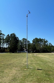
Our Weather Station Hardware
Davis Vantage Pro 2. Anemometer height 20'


NOAA Forecast Scripts Courtesy of Saratoga Weather and Carter Lake Weather
This weather station is privately owned and operated,. Never base any important decisions that could result in harm to people or property on this weather information.
Advisory Information Unavailable, error fetching or reading data from the NOAA advisories server.


